Showing posts with label Central America. Show all posts

Wednesday, May 12, 2004

Log 22 - Belize & another inland trip including the Mayan ruins of Tikal

This log covers April 24th to May 8th, 2004 where we sail to Belize & enjoy yet another inland trip, including the Mayan ruins of Tikal


Belize map and our inland route

Geographically, Belize forms the southeast region of the Yucatan Peninsula, a narrow strip of land squeezed between the Caribbean Sea and eastern Guatemala, with Mexico's Yucatan to the north.  Along its eastern shore the country is blessed with the Western Hemisphere's largest barrier reef, which is second in the world only to the one in Australia.  Until 1973 it was known as British Honduras , it became independent in 1981, and remains a member of the Commonwealth of Nations.  Though it is in the heart of Central America, by temperament and stability, it is far removed from the civil turmoil associated with some of it's neighbors.  It is English-speaking and the Belizean waters are among the finest in the western Caribbean for sailing and cruising.  Too bad our time here is so short, but hurricane season is fast approaching and we need to get out!


Sunday, April 25th, 2004 -  Half Moon Caye on Lighthouse Reef, Belize

We depart Honduras with just enough light to safely navigate out of the anchorage, on an overnight passage to Lighthouse Reef, one of only 4 coral atolls in the Western Hemisphere.  The passage is rough and fast and we have to heave-to (stop the boat) for 3 hours in order to not arrive before daylight.  After some confusion, we finally find the entrance in through the main reef and then pick our way safely through the smaller reefs to the anchorage just off  Half Moon Caye, a bird sanctuary and the first national park created by the Belizean government after independence from Britain in 1981. The water colors are astounding with clarity never experienced before. It is so odd to be anchored with 12 inches under our keel rather than the usual 25 feet!  A refreshing swim finds conch shells all about still inhabited by their little creatures and a manta ray swims right under our boat within meters of us!


Shallow waters of Half Moon Caye

Sailing about the bay in Boomerang the dingy. 

Monday, April 26th, 2004  - Gerrit's 8th birthday - Half Moon Caye, Belize

Gerrit really wanted to be in Belize for his birthday and we made it! 

       Happy 8th Birthday, Gerrit!


We spent his special day on shore with the Atalanta's.  First, we hiked the nature trail around the island on the beautiful, white sand path.

Half Moon Caye Natural Monument hike. 

The interpretive signs tell of the changes Hurricane Mitch (1998) made to the island…one beach is wiped out while another is made a lot bigger. It is also clear where trees were snapped off like toothpicks.   Huge iguanas scuttle about while the frigate birds and red-footed boobies nest in the trees all about. We climb up to the platform called the 'bird observatory' and enjoy a view from the same height as the tree tops into all the birds nests filled with babies. Some are already quite large, while others are clearly newly hatched. After a snorkel and play on the beach, we head back to Tioga for Gerrit's birthday supper, blackberry pie and gifts!


Gerrit gets a harmonica from the crew of s/v Atalanta.

Thursday, April 29th, 2004 - Belize and Guatemala inland trip begins

We arrived yesterday to Cucumber Beach Marina, just outside Belize City, strictly as a secure place to leave Tioga and Atlanta in order for the families to do one last inland trip together.  The rental van arrived around noon and we were all loaded and ready to leave by 1pm. Yes…another excellent adventure for Tioga and Atalanta!

Typical van we would rent to accommodate 2 families. 

We drove straight to JB's restaurant which was recommended to us for a late lunch. The setting was quaint amongst much greenery and a great view behind us as we sat on the patio. Lunch was typical Belizean and consisted of stewed chicken with a mixture of rice and beans. Very tasty.

Inland trip begins.  JBs for lunch.

Thursday, April 29th, 2004 - Belize Zoo

After lunch, it was off to the Belize Zoo just down the road. It is home to a variety of indigenous Belizean cats and other animals kept in totally natural surroundings. The land has not been cleared, it is as if cages just appeared from nowhere and paths cut for tourists. The zoo got its start after the shooting of a wildlife film entitled 'Path of the Raingods'.  By the time filming was over, the animals were partly tame and thus might not have survived well in the wild. Now, it is also home to orphaned, confiscated or injured animals as well. We were especially impressed by this keel-billed toucan's bright colors.

Beautiful keel-billed toucan


As well as this tapir, Belize's national animal. 

A tapir - they like to point their backsides at you and ...squirt...


The zoo was also home to gibnuts or paca, a sort of rodent type animal, which was served to the Queen of  England on her last visit, jaguars, which were blacker than night, howler monkeys with a baby teetering in the branches right above our heads, grey wolf pups who thought they were hidden between two tree trunks (so cute), and the majestic Harpee Eagle, what an impressive bird!   A few hours drive found us in the village of Bullet Tree, named after the tree with the 2nd hardest wood in Belize (Iron Wood tree being the hardest), where we had booked rooms at the Parrots Nest Lodge.

Beautiful little accommodation at Parrots Nest Lodge. 

Friday, April 30th, 2004 - Mountain Pine Ridge Forest Reserve

Western Belize has lots of beautiful, unspoiled mountain country dotted with waterfalls and teeming with exotic flora and fauna.  Almost 800 sq. km. to the south and east of the town of San Ignacio has been set aside as the Mountain Pine Ridge Forest Reserve.  We hire a local guide, Teddy, for the day to help us navigate the rough forest roads which are often impassable in the wet season, and not much better now, late into dry season!    On our way to the Barton Creek caves, the road oddly enough passed through an Amish-type community of European descendants.  We saw horse and carts with men who don't shave in uniform type clothing.  Apparently, they live in the back country where they literally live off the land and don't let things like electricity and modern machinery into their lives.

Fording a river in the Mountain Pine Ridge forest

1:50 pm - Barton Creek Caves

Next we arrive at the Barton Creek caves, believed to be the entrance to the underworld by the Maya who lived here for centuries in total dark.    To go inside the caves, we rent a couple of canoes from some Canadians from Ontario who operate a rental place at the site and head into the cave. 

Into the Barton Creek caves. Ginny and Michael.
Our canoes are rigged with a battery and lights and once inside the cave, we pull the canoes side by side and proceed as a single unit.   Stalagmites grow from the ground meeting the stalactites growing from the ceiling in places. Apparently they grow up to 1 inch per year as the water drips leaving the mineral, or sediment of calcium to grow. It would appear that eventually access to the caves will be closed off as passage is already quite tight in spots. Teddy tells us the Maya lived in these caves as they were much less harsh than the jungle surrounding the area. Teddy would point out pottery and human skulls on the edges of the cave, placed there for tourists to see but none the less, found in the cave.  At one point, we stopped and shut all the lights off and everyone was silent. Really cool feeling as your eyes would scramble for something to grasp onto. Absolute and total darkness and silence…a sensation our society totally lacks these days.  As the water would drip from the ceiling and stalactites, Teddy spoke about it being good luck to have a drop fall into your mouth. We maneuvered the canoes numerous times in order for us all to have claim to this good omen!    There was black goo on the wall as a sign bats live here and sure enough, Teddy shines his light into some crevasses to reveal bats hanging onto one another throughout the cave.  At the last bend on the way out, we turned the lights out again until we rounded the corner and daylight flooded us once again.

Drip ... drip ... drip ...

5:11 pm - Hidden Valley Falls

After a picnic lunch, we head off to swim at the Hidden Valley Waterfalls, a silver cascade which plunges almost 500 meters!  Everyone swam to the foot of the falls and then took turns climbing right up inside the waterfall.  There was a lot of current and force as the water tumbled over you so bracing oneself very well was a must.   A few brave souls including Joel and Gerrit, climbed the cliffs in order to jump into the pool below the falls....'yikes', says Sheila.   After a few final stops to admire views, we return to San Ignacio for a great supper at a family restaurant called Hode's.

Refreshing Hidden Valley Falls. We dive from the middle rocks.

Saturday, May 1st, 2004 - San Ignacio, Belize - Iguana Project

The San Ignacio Hotel houses a 'raise and release' iguana project with the aim of increasing the iguana numbers in the wild.  Today's guide, Martin, was an incredibly patient and gifted teacher who allowed us all a totally cool homeschooling learning experience.

The kids with Martin the iguana keeper


Baby iguana
The story goes something like this.  Once inside the iguana green house, Martin had the kids spotting as many iguanas as they could.  There were over 30 baby iguanas, but their bright green color totally camouflaged them and they were hard to spot! Apparently, they remain this bright green until they are about 2 years old so they are camouflaged on the ground and are not such easy prey.

Joel spotted a large, grown-up iguana. Martin began to explain that she was a mother about to lay eggs. He looked at her and her abdomen was totally caved in…he excitedly explained she must have just laid her eggs within the past 30 minutes because the last time he saw her, she was huge and barely able to move. Martin found the spot she laid the eggs and let the kids gently dig them out! They took turns digging eggs and laying them orderly to the side..all 46 of them!!. They were very soft and felt much like leather. Then, Martin brought down a container for the kids to gently put the eggs into and he let them carry the bin up to the incubator where they were able to transfer the eggs into the incubator and cover them with soil where they will incubate for about 90 days before hatching.

Eggs get buried in the incubator

He then had the kids help him inspect the mother for ticks to ensure she was healthy. He also showed us iguanas have a third eye (tertiary eye) on top of their heads to see above them. We then all walked with him down to the Macal River where she was to be released now that she had laid her eggs in captivity. All the kids got to take turns carrying the mother and finally she was released in the water. She was still in 'hiding from us' mode and she lay there for about a minute before realizing she was free and off she went in a flash!

Mother iguana about to be released after laying eggs in captivity. 

After a quick lunch, we cross the border in Guatemala and drive to the town of El Peten and checked into La Casa De Don David. Very nice place with a lush green fresh garden and a huge gazebo with hammocks all about. The kids ran to their hearts content while we relaxed before supper. Off to the Mayn ruins at Tikal tomorrow.

Monkeys all about.

Sunday, May 2nd, 2004 - Ancient Mayan city of Tikal, Guatemala

Wow, where to begin with this grand Mayan city.  At its height of time, it sprawled over 30 sq. kms. so you can imagine we did not even scratch its surface in our short day trip here.  Its towering pyramids rise out above the jungle's green canopy to amazing heights.

Temple I from behind
Tikal's long history is believed to have begun around 700BC when the Maya settled here. Maya Civilization, an ancient Native American culture, represents one of the most advanced civilizations in the western hemisphere before the arrival of Europeans.   By the time of Christ, Tikal's Great Plaza was beginning to take it's present shape and by 250AD, Tikal was an important religious, cultural and commercial city with a large population, accounts of 50,000-100,000 people.  By the mid 500's it was at its height but it took a turn for the worse for a couple hundred years when the people of another great Mayan city, Caracol (in south-west Belize) conquered Tikal's king and sacrificed him.  Around 700AD, a new and powerful king named 'Ah-Cacau '(Lord Chocolate) restored not only its military strength, but its status as the most splendid city in the Mayan world.  He and his successors were responsible for building most of the great temples around the Great Plaza, which survive today.  The towering Temple 1 ( Temple of the Grand Jaguar), was built by Ah-Cacau's son who succeeded his throne, to honour and bury the great King Ah-Cacau under it.  The greatness of Tikal collapsed around 900AD as part of a mysterious general collapse of Mayan civilization.

Temple I from above the Grand Plaza
The Great Plaza and its surrounding constituted the core of Tikal.  We explore about and then it's time for the big climb.

Inside the Grand Plaza


Eerily Temple IV sits off in the jungle. 

We walk through the jungle over to Temple IV.


Steps up to Temple IV


At 64 metres, it is the highest Indian building known in the western hemisphere.  It was completed in 741AC, in the reign of Ah-Caca's son.  We clamber up the steep steps and climb to the base of the roofcomb for yet another wonderful view above the canopy.


View from the top of Temple IV


Gerrit still having fun the the down pour.
Chris, the weatherman, however also spots ominous dark clouds in the distance and suggests we all make a break for the museum at the entrance.  But his warning falls on unreceptive ears and the rest of us persist in some further stops.  Well, we get caught big time by what appears to be the season's first big rain!  We wait and wait all huddled under a picnic canopy along with tons of other locals as the sheets of rain come down.  After about 2 hours, we realize this rain is not stopping and we make a run for it.  We are a long way from our van so everyone is totally soaked by the time we get there.   Next time, we'll listen to Chris!


Monday, May 3rd, 2004 - Ferry crossing

On our way back to the marina, we decide to stop at one last Mayan site, Xunantunich (pronounced shoo-nahn-too-neech).  In order to access it, we must take this small, hand- cranked ferry across a river.

Car ferry to Xuantunich

Monday, May 3rd, 2004 - Ancient Mayan City of Xunantunich, Belize

The Belizeans claim this to be the best Mayan site in Belize, thus it is their archaeological pride.  Xunantunich, meaning 'stone maiden', is set on a leveled hilltop overlooking the Mopan (or Belize) river.  Not much is known about this tiny ruin except that it controlled the riverside track leading from Tikal in Guatemala down to the Caribbean Sea and a ceremonial centre flourished here during the Classic period.   Archaeologists have uncovered evidence of a damaging earthquake in about 900AD, after which it may have been largely abandoned.  We found it a very nice,well maintained site that was a great size for the kids to easily run about and explore.

Beautiful vistas at Xunantunich


Intricate carvings on el Castillo

The tallest structure 'El Castillo', is very impressive as it rises some 40 meters above the jungle floor.  It contains a late dated 'frieze', or decorative horizontal band, depicting images from classic Mayan mythology.  Friezes were often an important feature in ancient temples.  We climbed to the top of this structure where kings of the past would have addressed their people expecting full attention.  Funny, Chris and Michael tried getting the people mulling about down below to address them with out any luck at all!  Our tour of Xunantunich completed our inland trip and it was back to the boats with a quick depart on our minds.


Wednesday, May 5th, - Working our way north through the reefs

The excellent cruising grounds north of Belize City are where the larger island settlements are found.  Eyeball navigation is tricky in these shallow waters as greenish water prevails over the shallow grassy flats, thus constant reference to guide books and exact position must be known.  There are areas of controlling depths of 5.5 feet thus we travel at high tide to give us some slack as we move from cay to cay.   We spy this local vessel way out ahead of us and...the race was on.  As we passed him, we called out to him, 'what a beautiful boat'!   It turned out we saw this vessel numerous times in our travels.

Working our way through the reefs

Friday, May 7th, - Town of San Pedro, on Ambergris Cay, Belize

We finally reach Ambergris Cay, which as an island, is the northernmost barrier reef cay in Belize.  It is named after the gray waxy substance excreted by sperm whales and used in perfume, which was found on these beaches by early explorers.  We anchored just off the town of San Pedro, an attractive fishing town that is exploding with tourism.

San Pedro's main street on Ambergris Cay


Its clapboard houses with immaculate, hard-packed sand roads lined with colorful shops and restaurants, were fun to explore in the golf cart we rented.


Crazy Canucks Bar in San Pedro

We even found the 'Crazy Canuck' bar on the beach that was recommended to us by our friends whom recently visited here from Calgary.  The owner of the bar is another Calgarian trying to make a go of it as this tiny island becomes more and more known.


No this isn't our check out of Belize.

Our final check-out from Belize is also done here as we are awaiting weather to cross the Caribbean Sea with a landfall of Cuba in our sights.  Saturday, May 8th produces a go-now or wait-a-week weather window so we enjoy one last night out in San Pedro with our good friends on s/v Atalanta and then Sunday morning, it is 'good-bye' as Tioga heads out on a long passage alone for the first time since our travels back in Mexico.   Cuba, here we come!


Next up is Cuba in Log 23.  Join us as we make our way through the reefs.  

Sunday, April 25, 2004

Log 21 - Panama & San Blas Islands, Isla Providencia (Columbia) & Honduras

This log covers from March 22nd through April 22nd, 2004.  We spend time in some really unique locations between the San Blas Islands and Roatan, Honduras.  We are even far enough south that we are seeing the constellation of stars called the Southern Cross.  Really special.  


Our route from Panama to Cuba We are now through the Panama Canal and into the Caribbean and a whole new ocean.  We don't have a lot of time to cruise if we still plan on crossing the Atlantic Ocean to Europe in early June.  This vexing question, to cross or not, weighs heavily on our minds as we work our way north.   Let alone the worries of actually making a trans-Atlantic passage, we have to keep the pace up in order to even have the option to cross before the hurricane season.  Further, as we soon discover, the weather does not want to cooperate

Panama & San Blas Islands, Isla Providencia (Columbia) & Honduras

Friday, March 26th - Exploring the mighty Chargres River

We anchored outside of Colon on the Atlantic side of the Panama Canal, waiting for extremely strong easterly winds and seas to lay down.  These winds had holed cruisers up in Colon for at least 3 weeks, and we were running into people we thought had been long gone. We hear that one can anchor in the beautiful and nearby Chargres River, which sounds a lot better than a crowed anchorage in Colon.  So, with a fresh set of GPS waypoints, we pick our way over one blustery afternoon and find an exotic and deserted place, complete with a well-preserved Spanish fort, moat, and cannons.

Most tropical anchorage ever. 


Fort San Lorenso overlooking the Chargres River


Prior to its role in supplying fresh water to the Panama Canal, the Chargres River was an important waterway, minimizing the distance between the Pacific and Atlantic Oceans.   Through here the Spaniard's ferried treasure unloaded from galleons in the city of Panama on the Pacific - gold of Peru and the silver of fabulous Potosi in Bolivia - and then loaded them again on this side into galleons bound for Spain.  In 1671, British privateer, Henry Morgan, broke through the defenses of Fort San Lorenzo, got up river and sacked and destroyed the original Panama City.  Solitude and beauty now envelope the river like a jungle mist.  It is one of our favourite stops yet; fresh water to swim in, howler monkeys, squawking parrots, a toucan, an incredible fragrance, and a fascinating past.

Joel & Gerrit act out characters from Brian Jacques Redwall series.

Sunday, March 28th - Portobelo, Panama

After the Chargres, we sail to Portobelo, one of Panama's most important historic sites.  Named the "beautiful port" in 1502 by Christopher Columbus on his 4th and last New World voyage, it was the principal Spanish Caribbean port in Central America for about 200 years.  Here to, treasure arrived from Panama City by mule train and was stored in this fortress waiting for galleons laden with goods from Spain to arrive to trade for the gold.  We had a great day exploring around this site.

Beautiful Portobelo harbor - Columbus anchored here, too!

A local historian, who lives in Portobelo (and who says Columbus was a "washed-up old man" by the time he arrived here), takes the time to show us his treasure collection, including a gold doubloon, four pieces-of-eight, and other silver coins.

Spanish treasure

Tuesday,  March 30th - Panama's San Blas Islands

Well, after an overnight trip from Portobelo we enter into the shallow waters and reefs surrounding the Lemon Cayes (keys) of the San Blas Islands, an archipelago of about 378 reef-studded islands.   Winding our way through the reefs, Sheila is at the helm and Chris is up on the boom to watch water colors - color correlates with depth. While Sheila white-knuckles the helm, Chris keeps her calm as he can see the reefs from above! Yikes….. We barely drop anchor when the Kuna Indians arrive to sell us their handicrafts.  The Kuna Indians are a matriarchal society, which means the ladies are the boss, and the guys do what they are told (same as in Canada and the US!).

Kuna Indian family visit in their dugout canoe

Thursday, April 1st -  Lemon Cayes

Today, we return to an island close by to our anchorage and called Kagandup, where a family we met yesterday lives. Joel has made bracelets for the two young girls and the two women. Each of them holds out their hand for him to put them on. The little girl named Itxa (4 years old) puts on a beautiful blouse, along with a little crown and does a dance for us in thanks.

Little Itxa does a dance for us


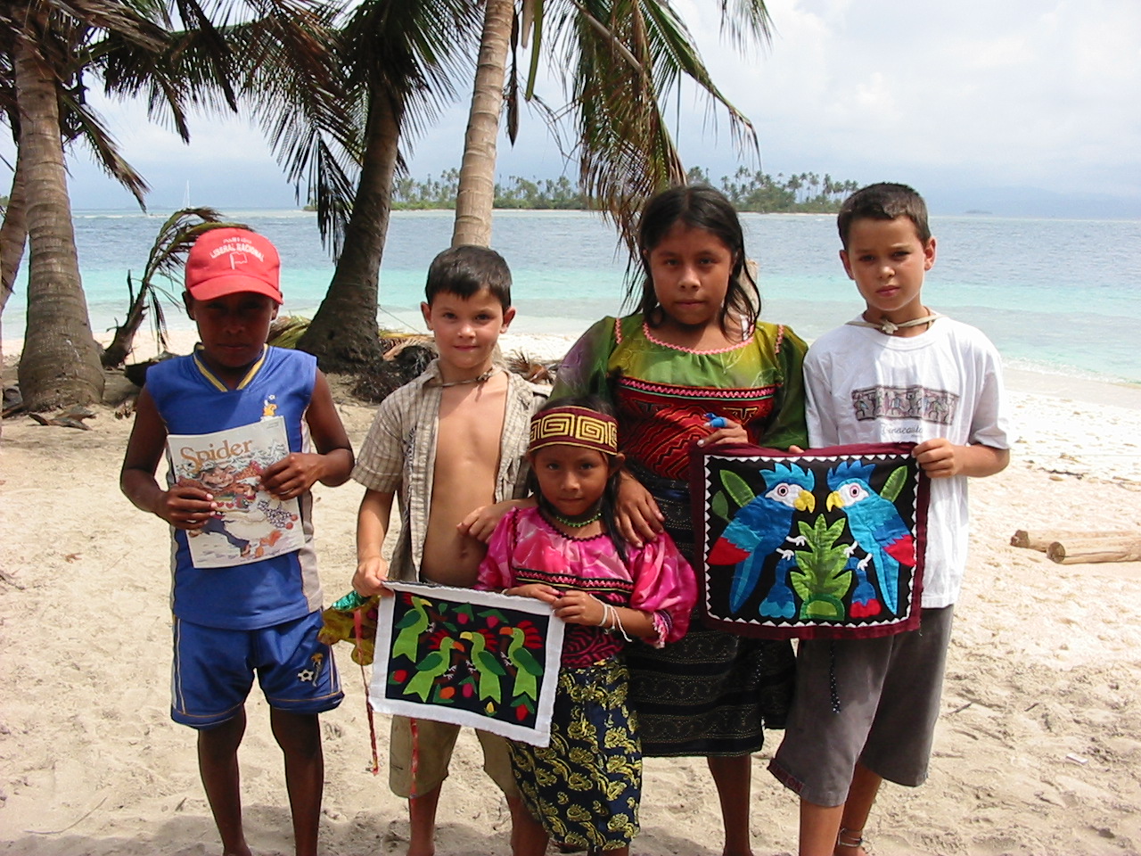
We give the older girl, Nedelka (14 years old) along with her brother Ronal (11 years old) some kids' magazines and they all pose for a picture with Joel and Gerrit along with the 'molas' the boys chose.

Kids meeting other kids
What is a mola you ask?  The San Blas Islands are becoming quite famous worldwide for this handicraft. The Kuna women dress very colorfully with intricate beadwork on their arms and legs, some face painting and orange scarves, earrings, and gold rings.  But the most eye-catching of all are their blouses or  'molas.'   These are intricately designed and sewn panels that they wear on their fronts and backs. Now they make mola designs that can be used for pillows, wall hangings, frames, etc. and that have earned them a world-wide reputation for a unique art-from.  The Kuna women are now serious cash earners.

Mola made by this lovely lady. 

Friday, April 2nd - Village of Gaigar

As if yesterday wasn't enough culture shock, today we sail to and visit a tiny island village called Gaigar.   As background (that we are sure you want to know) the Kuna Indians are a very tenacious people who appear to have changed little from the times before the Spanish Conquests. After suffering from violent inroads by outsiders, the Kuna rebelled in 1925 against Panama. A bloody retribution was prevented with the intervention of the US (active in the nearby Canal Zone) and in 1938, the government of Panama granted the Kuna leaders almost autonomous rule in the officially recognized Comarca de San Blas. The traditional hierarchy of tribal leaders on national and village levels has provided the cohesion that makes the 55,000 Kunas one of the strongest among indigenous Americans. Their law that the land belongs to all Kunas has prevented the division of the people into 'haves' and 'have nots' and has helped them perceive themselves as the blessed co-owners of these wonderful islands. At the village level, the first sahila (the chief, pronounced see-la) holds the highest position and he presides over a local daily congresso along with 2-3 deputy sahilas. In order to visit this village, we first had to get permission from the sahila.   We were summoned to the meeting hut (congresso) and, after Chris introduces the family and gives the sahila $10, we receive permission to explore their village and a nearby river.  Sheila purchases a stunning mola shown in the picture and after the boys join in with the school kids in game of futbol (soccer).

Inside the Kuna village of Gaiger

Game of soccer with Kuna kids

Saturday, April 3rd - Exploring up the Rio Esadi

Having received permission from the sahila yesterday, today we take our dinghy and go a mile or so up the Esadi River for an explore and hike through the shady lowland rain forest.   The Kuna Indians use this river and others like it for access to the interior, where the men spend the days harvesting mangos, roots, and other edible plants.   There are many well-used trails taking off into the jungle.  We tie up our dinghy and head up one that our guide book says will lead us up to a view point.  Our hike takes us through lush valleys and banana groves with great views now and then. At one point, we can see a small speck of Tioga off in the distance.

Heading up the Esadi River
More dinghy exploring

Here's a closer look at a flowering banana plant, of which there are many along our trail.  Here, in the tropics the stems are annual—that is, they die after perfecting the fruit, and new stems are developed from buds in the rootstock.   It takes about 10 months to go from bud to ripened fruit. The flowers spring in great spikes from the center of the crown of leaves and are arranged in whorl-like clusters along the spike; the female flowers occupy the base of the spike, and the male the apex.  The fruits vary in length from about 10 to 30 cm (about 4 to 12 in). The average weight of a bunch is about 11 kg (about 25 lb), but individual bunches often exceed 18 kg (40 lb). A stalk bears only once, dies down, and is replaced by sprouts, two or three of which are allowed to bear fruit.

Banana plant in flower

Back to our exploration, there's another path leading off the main trail and up to a Kuna cemetery. Kuna cemeteries are usually close to rivers on choice sites with the best views, and this one is no exception. The thatched roofs on poles shade the shallow clay graves adorned with everyday cooking and household utensils for use in the afterlife. We try to imagine what a funeral would be like. All the dug out canoes heading out from the small nearby village of Maquina, one carrying the body to its final resting place. We imagine the ceremony that would accompany it…probably quite remarkable.

Kuna cemetary - a family site

Tuesday, April 6th - Arrival in Isla Providencia, Colombia

We enjoyed ourselves immensely in the San Blas Islands, but weather is also king and lately uncooperative.  So when a small weather-window presents itself to sail north for 300 miles to the Colombian island of Providencia, we decide to go for it.  This island and Isla San Andres, its neighbor to the SW, both have extremely colorful pasts involving Caribe tribes, English pirates, Spanish colonists and African slaves.  Today, it's a blend of everything and anything goes.

Colorful church in Providencia

Thursday, April 8th - Scootering around Isla Providencia

There's lots to do on this island and today is no exception.  In fact it is a hoot!  We and our buddy-boaters from s/v Atalanta rent scooters and set of to circumnavigate the island.

Scooter gang on Isla Providencia
Now that is beautiful blue water.

Friday, April 9th - Good Friday in Providencia

Today is Good Friday of Semana Santa or Holy Week - the day Christians worldwide reflect on the crucification of Jesus Christ.  We participate in a procession through the streets and the 14 Stations of the Cross.  At each station, there is a reenactment of the events that occurred along the route Christ was taken to Calvary, where he then died on a cross.  The procession ends at the church.

Good Friday procession in Providencia
The kids get right up in front of this poignant procession, and in our minds, the events that we want to remember and celebrate galvanize in their little heads much more then with a hard bench beneath their bottoms.


Stations of the Cross

Sunday, April 11th - Easter Dinner

Our Easter dinner was thoroughly enjoyable.  We had the foresight to pre-order two roast chickens and a pile of roast potatoes from a nearby roastarria, so there wasn't much cooking left to be done to augment things.  Tomorrow, we will get underway again heading north and west for the Bay Islands of Honduras.

Happy Easter from Sheila, Michael, Ginny and Chris!
Kid party down below of Atalanta.

April 12th through April 18th - En route to the Bay Islands of Honduras

Once again, we are pressed to snag a fleeting weather window and continue our passage northward from Isla Providencia to Roatan, the largest of the Honduran Bay Islands.  Our intermediate objective is to round the shoulder of Nicaragua (but not too closely as a dispute still exists over territorial waters) and potentially stop and explore some offshore islands and reefs.


 We have a beautiful sail, but by mid-day April 13th the latest weather information has a fast approaching storm in our way.   On the advice of a boat with experience in these waters (Queen Mary), we indeed pull into Vivarillos Cays.  Apparently, these waters will get ugly fast!    We get two anchors down in anticipation for the storm and are glad.  For four nights we hole up.  Finally on the morning of April 17, we raise anchor and commence the overnight passage to Roatan, about 180 miles away to the west.  Though the passage is not uncomfortable from a sickness point of view, it is slightly unnerving as we are still in +30 knots of wind with constant 7-9 foot seas with the occasional 10 foot set rolling thorough. Tioga handles it great, it is just us land lubbers who get tense and swear Tioga is going home via Halifax! We end up putting up half of our cockpit enclosure just to stop the spray and boarding seas.  Finally day breaks on April 18th and we only have 30 miles to go to French Beach on Roatan.  We decide to tie up in the marina as it boasts a pool, showers and potable water. Also the chance to charge our badly run down batteries. We shut things down just after 1pm, exhausted!  That evening, we decide to eat at the marina's restaurant. It is slightly expensive, the food not so great, but it fit the bill for some tired old people and their hungry kids.

View from Roatan 


In Log 22 we discover Belize and the ruins of Tikal.  Join us :)