This log covers from March 22nd through April 22nd, 2004. We spend time in some really unique locations between the San Blas Islands and Roatan, Honduras. We are even far enough south that we are seeing the constellation of stars called the Southern Cross. Really special.
Our route from Panama to Cuba
We are now through the Panama Canal and into the Caribbean and a whole new ocean. We don't have a lot of time to cruise if we still plan on crossing the Atlantic Ocean to Europe in early June. This vexing question, to cross or not, weighs heavily on our minds as we work our way north. Let alone the worries of actually making a trans-Atlantic passage, we have to keep the pace up in order to even have the option to cross before the hurricane season. Further, as we soon discover, the weather does not want to cooperate
 |
| Panama & San Blas Islands, Isla Providencia (Columbia) & Honduras |
Friday, March 26th - Exploring the mighty Chargres River
We anchored outside of Colon on the Atlantic side of the Panama Canal, waiting for extremely strong easterly winds and seas to lay down. These winds had holed cruisers up in Colon for at least 3 weeks, and we were running into people we thought had been long gone. We hear that one can anchor in the beautiful and nearby Chargres River, which sounds a lot better than a crowed anchorage in Colon. So, with a fresh set of GPS waypoints, we pick our way over one blustery afternoon and find an exotic and deserted place, complete with a well-preserved Spanish fort, moat, and cannons.
 |
| Most tropical anchorage ever. |
 |
| Fort San Lorenso overlooking the Chargres River |
Prior to its role in supplying fresh water to the Panama Canal, the Chargres River was an important waterway, minimizing the distance between the Pacific and Atlantic Oceans. Through here the Spaniard's ferried treasure unloaded from galleons in the city of Panama on the Pacific - gold of Peru and the silver of fabulous Potosi in Bolivia - and then loaded them again on this side into galleons bound for Spain. In 1671, British privateer, Henry Morgan, broke through the defenses of Fort San Lorenzo, got up river and sacked and destroyed the original Panama City. Solitude and beauty now envelope the river like a jungle mist. It is one of our favourite stops yet; fresh water to swim in, howler monkeys, squawking parrots, a toucan, an incredible fragrance, and a fascinating past.
 |
| Joel & Gerrit act out characters from Brian Jacques Redwall series. |
Sunday, March 28th - Portobelo, Panama
After the Chargres, we sail to Portobelo, one of Panama's most important historic sites. Named the "beautiful port" in 1502 by Christopher Columbus on his 4th and last New World voyage, it was the principal Spanish Caribbean port in Central America for about 200 years. Here to, treasure arrived from Panama City by mule train and was stored in this fortress waiting for galleons laden with goods from Spain to arrive to trade for the gold. We had a great day exploring around this site.
 |
| Beautiful Portobelo harbor - Columbus anchored here, too! |
A local historian, who lives in Portobelo (and who says Columbus was a "washed-up old man" by the time he arrived here), takes the time to show us his treasure collection, including a gold doubloon, four pieces-of-eight, and other silver coins.
 |
| Spanish treasure |
Tuesday, March 30th - Panama's San Blas Islands
Well, after an overnight trip from Portobelo we enter into the shallow waters and reefs surrounding the Lemon Cayes (keys) of the San Blas Islands, an archipelago of about 378 reef-studded islands. Winding our way through the reefs, Sheila is at the helm and Chris is up on the boom to watch water colors - color correlates with depth. While Sheila white-knuckles the helm, Chris keeps her calm as he can see the reefs from above! Yikes….. We barely drop anchor when the Kuna Indians arrive to sell us their handicrafts. The Kuna Indians are a matriarchal society, which means the ladies are the boss, and the guys do what they are told (same as in Canada and the US!).
 |
| Kuna Indian family visit in their dugout canoe |
Thursday, April 1st - Lemon Cayes
Today, we return to an island close by to our anchorage and called Kagandup, where a family we met yesterday lives. Joel has made bracelets for the two young girls and the two women. Each of them holds out their hand for him to put them on. The little girl named Itxa (4 years old) puts on a beautiful blouse, along with a little crown and does a dance for us in thanks.
 |
| Little Itxa does a dance for us |
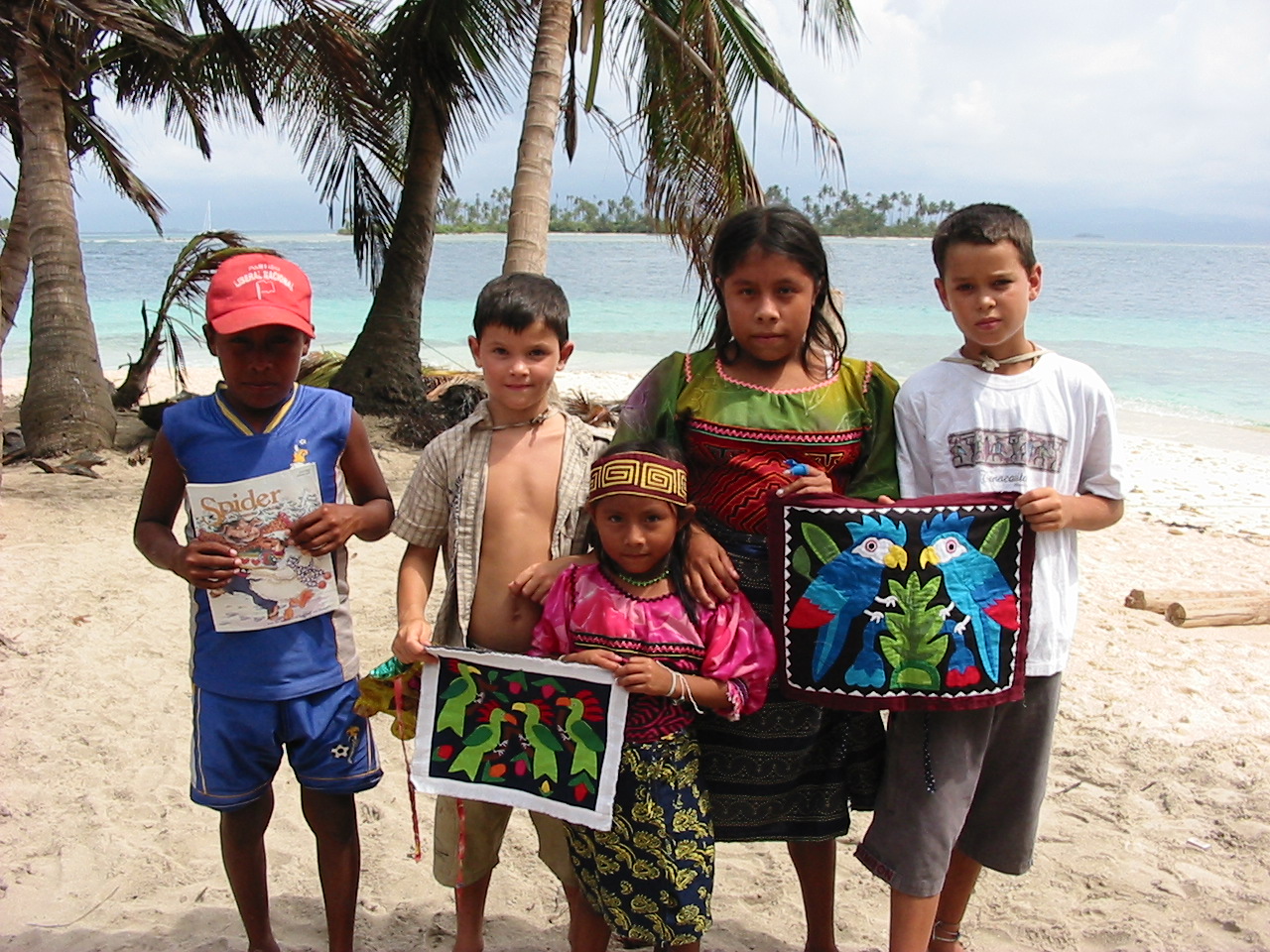
We give the older girl, Nedelka (14 years old) along with her brother Ronal (11 years old) some kids' magazines and they all pose for a picture with Joel and Gerrit along with the 'molas' the boys chose.
 |
| Kids meeting other kids |
What is a mola you ask? The San Blas Islands are becoming quite famous worldwide for this handicraft. The Kuna women dress very colorfully with intricate beadwork on their arms and legs, some face painting and orange scarves, earrings, and gold rings. But the most eye-catching of all are their blouses or 'molas.' These are intricately designed and sewn panels that they wear on their fronts and backs. Now they make mola designs that can be used for pillows, wall hangings, frames, etc. and that have earned them a world-wide reputation for a unique art-from. The Kuna women are now serious cash earners.
 |
| Mola made by this lovely lady. |
Friday, April 2nd - Village of Gaigar
As if yesterday wasn't enough culture shock, today we sail to and visit a tiny island village called Gaigar. As background (that we are sure you want to know) the Kuna Indians are a very tenacious people who appear to have changed little from the times before the Spanish Conquests. After suffering from violent inroads by outsiders, the Kuna rebelled in 1925 against Panama. A bloody retribution was prevented with the intervention of the US (active in the nearby Canal Zone) and in 1938, the government of Panama granted the Kuna leaders almost autonomous rule in the officially recognized Comarca de San Blas. The traditional hierarchy of tribal leaders on national and village levels has provided the cohesion that makes the 55,000 Kunas one of the strongest among indigenous Americans. Their law that the land belongs to all Kunas has prevented the division of the people into 'haves' and 'have nots' and has helped them perceive themselves as the blessed co-owners of these wonderful islands. At the village level, the first sahila (the chief, pronounced see-la) holds the highest position and he presides over a local daily congresso along with 2-3 deputy sahilas. In order to visit this village, we first had to get permission from the sahila. We were summoned to the meeting hut (congresso) and, after Chris introduces the family and gives the sahila $10, we receive permission to explore their village and a nearby river. Sheila purchases a stunning mola shown in the picture and after the boys join in with the school kids in game of futbol (soccer).
 |
| Inside the Kuna village of Gaiger |
 |
| Game of soccer with Kuna kids |
Saturday, April 3rd - Exploring up the Rio Esadi
Having received permission from the sahila yesterday, today we take our dinghy and go a mile or so up the Esadi River for an explore and hike through the shady lowland rain forest. The Kuna Indians use this river and others like it for access to the interior, where the men spend the days harvesting mangos, roots, and other edible plants. There are many well-used trails taking off into the jungle. We tie up our dinghy and head up one that our guide book says will lead us up to a view point. Our hike takes us through lush valleys and banana groves with great views now and then. At one point, we can see a small speck of Tioga off in the distance.
 |
| Heading up the Esadi River |
 |
| More dinghy exploring |
Here's a closer look at a flowering banana plant, of which there are many along our trail. Here, in the tropics the stems are annual—that is, they die after perfecting the fruit, and new stems are developed from buds in the rootstock. It takes about 10 months to go from bud to ripened fruit. The flowers spring in great spikes from the center of the crown of leaves and are arranged in whorl-like clusters along the spike; the female flowers occupy the base of the spike, and the male the apex. The fruits vary in length from about 10 to 30 cm (about 4 to 12 in). The average weight of a bunch is about 11 kg (about 25 lb), but individual bunches often exceed 18 kg (40 lb). A stalk bears only once, dies down, and is replaced by sprouts, two or three of which are allowed to bear fruit.
 |
| Banana plant in flower |
Back to our exploration, there's another path leading off the main trail and up to a Kuna cemetery. Kuna cemeteries are usually close to rivers on choice sites with the best views, and this one is no exception. The thatched roofs on poles shade the shallow clay graves adorned with everyday cooking and household utensils for use in the afterlife. We try to imagine what a funeral would be like. All the dug out canoes heading out from the small nearby village of Maquina, one carrying the body to its final resting place. We imagine the ceremony that would accompany it…probably quite remarkable.
 |
| Kuna cemetary - a family site |
Tuesday, April 6th - Arrival in Isla Providencia, Colombia
We enjoyed ourselves immensely in the San Blas Islands, but weather is also king and lately uncooperative. So when a small weather-window presents itself to sail north for 300 miles to the Colombian island of Providencia, we decide to go for it. This island and Isla San Andres, its neighbor to the SW, both have extremely colorful pasts involving Caribe tribes, English pirates, Spanish colonists and African slaves. Today, it's a blend of everything and anything goes.
 |
| Colorful church in Providencia |
Thursday, April 8th - Scootering around Isla Providencia
There's lots to do on this island and today is no exception. In fact it is a hoot! We and our buddy-boaters from s/v Atalanta rent scooters and set of to circumnavigate the island.
 |
| Scooter gang on Isla Providencia |
 |
| Now that is beautiful blue water. |
Friday, April 9th - Good Friday in Providencia
Today is Good Friday of Semana Santa or Holy Week - the day Christians worldwide reflect on the crucification of Jesus Christ. We participate in a procession through the streets and the 14 Stations of the Cross. At each station, there is a reenactment of the events that occurred along the route Christ was taken to Calvary, where he then died on a cross. The procession ends at the church.
 |
| Good Friday procession in Providencia |
The kids get right up in front of this poignant procession, and in our minds, the events that we want to remember and celebrate galvanize in their little heads much more then with a hard bench beneath their bottoms.
 |
Stations of the Cross |
Sunday, April 11th - Easter Dinner
Our Easter dinner was thoroughly enjoyable. We had the foresight to pre-order two roast chickens and a pile of roast potatoes from a nearby roastarria, so there wasn't much cooking left to be done to augment things. Tomorrow, we will get underway again heading north and west for the Bay Islands of Honduras.
 |
| Happy Easter from Sheila, Michael, Ginny and Chris! |
 |
| Kid party down below of Atalanta. |
April 12th through April 18th - En route to the Bay Islands of Honduras
Once again, we are pressed to snag a fleeting weather window and continue our passage northward from Isla Providencia to Roatan, the largest of the Honduran Bay Islands. Our intermediate objective is to round the shoulder of Nicaragua (but not too closely as a dispute still exists over territorial waters) and potentially stop and explore some offshore islands and reefs.

We have a beautiful sail, but by mid-day April 13th the latest weather information has a fast approaching storm in our way. On the advice of a boat with experience in these waters (Queen Mary), we indeed pull into Vivarillos Cays. Apparently, these waters will get ugly fast! We get two anchors down in anticipation for the storm and are glad. For four nights we hole up. Finally on the morning of April 17, we raise anchor and commence the overnight passage to Roatan, about 180 miles away to the west. Though the passage is not uncomfortable from a sickness point of view, it is slightly unnerving as we are still in +30 knots of wind with constant 7-9 foot seas with the occasional 10 foot set rolling thorough. Tioga handles it great, it is just us land lubbers who get tense and swear Tioga is going home via Halifax! We end up putting up half of our cockpit enclosure just to stop the spray and boarding seas. Finally day breaks on April 18th and we only have 30 miles to go to French Beach on Roatan. We decide to tie up in the marina as it boasts a pool, showers and potable water. Also the chance to charge our badly run down batteries. We shut things down just after 1pm, exhausted! That evening, we decide to eat at the marina's restaurant. It is slightly expensive, the food not so great, but it fit the bill for some tired old people and their hungry kids.
 |
| View from Roatan |
In Log 22 we discover Belize and the ruins of Tikal. Join us :)